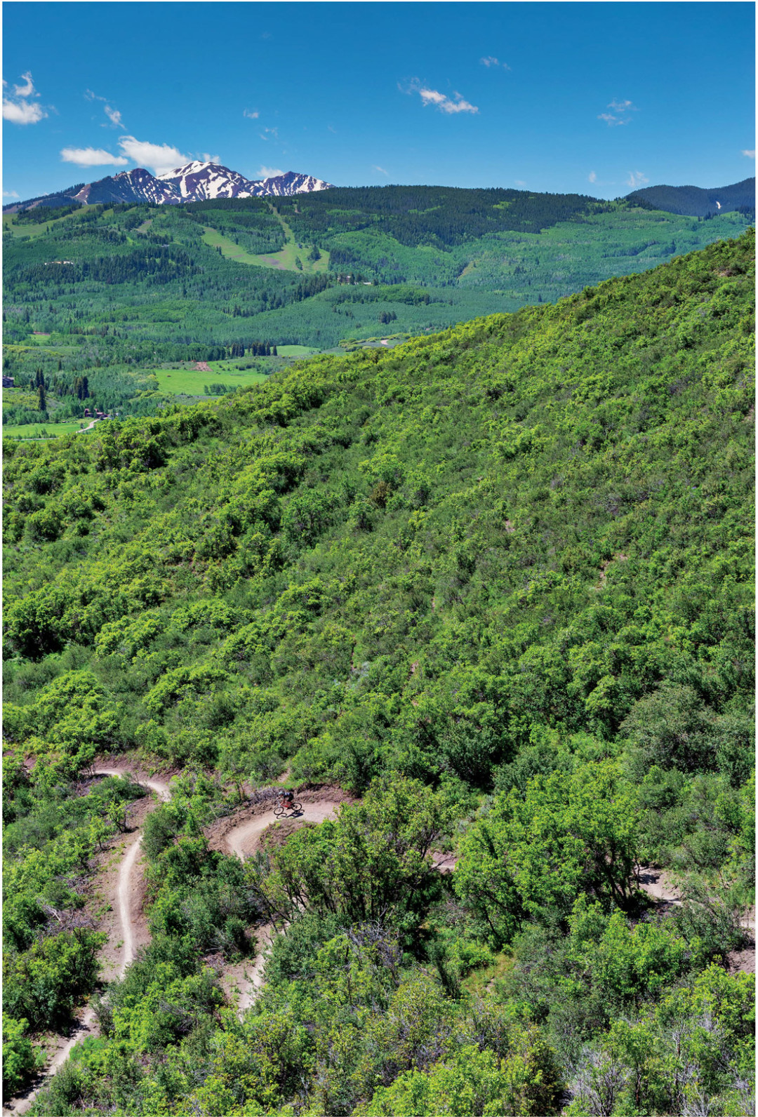
How does an 845-acre parcel with more than ten miles of trails connecting Aspen and Snowmass qualify as unknown? Because Sky Mountain Park has only been around (officially) since 2010, with some trails in the network opening just this summer. The trails—Airline, Cozyline, Skyline Ridge, Viewline, and Highline—are aptly named. They offer killer 360-degree views from the ridge that runs between Brush and Owl Creeks. The lineup features rolling and at times steep singletrack through sagebrush and scrub oak. Trails can be linked together for a big ride or sampled individually; all ride well in both directions. The undulating trail and banked switchbacks that ascend Airline when ridden from the Aspen side, for example, become rollicking whoop-de-doos, rollers, and banked turns as a downhill when you approach from the Snowmass side. Cozyline’s singletrack is nice and mellow for climbers, with wide switchbacks at its base that can make for a flowing finish big on turns. Skyline Ridge rides the toughest—getting to it alone is a challenge. It can be accessed by a switchback-laden uphill via Viewline or by pedaling a less intense climb from Cozyline. The whole of Skyline Park can be accessed three different ways: from the Owl Creek Trail on the Aspen side, from the Brush Creek Trail from the Intercept Lot, and from the Highline Trail from Snowmass Village.
Easy: Lincoln Creek Road Lincoln Creek Road, eleven miles up Highway 82 from Aspen toward Independence Pass, is perfect for cutting your mountain-biking teeth. Known for accessing great camping, this rugged, rocky 4WD road is also a perfect place for advanced beginners to work on their skills. Cycling instructor Erik Skarvan of Sun Dog Athletics (sundogathletics.com) routinely takes clients there, where he teaches techniques like spotting a line and navigating rockier areas, all amid quiet pines (and the occasional 4WD vehicle). Ride the road six miles to Grizzly Reservoir for a picnic before rolling back down.
Classic: Government Trail Gorgeous in any season, this ride between Aspen and Snowmass Village really shines during peak foliage in the fall. From Snowmass, you gain access through groves of aspen trees on the buff Tom Blake Trail and a lengthy singletrack ascent on Powerline Trail before reaching a 4WD road and hanging a left onto the Government Trail. After several beefy climbs and technical rock sections, you’ll traverse a pine forest with enough roots and creek crossings to keep things interesting. The last bit of technical rock feature is known as the Rock Garden. It’s tricky. From here, things open up with a full-throttle downhill singletrack as you traverse Buttermilk, from West to Tiehack. Just a couple of miles from the bottom of the mountain is the infamous Root, which originates from a tree that lies in the center of a tight downhill switchback. Ride the Root and prove your prowess, take the outside line, or just walk it. All options go. Charge downhill to the base of Tiehack for your finish, and cross this classic off your list.
Epic: Smuggler-to-Lenado Loop This is a ride that links several Aspen favorites to form something epic. It decrescendos from one of Aspen’s most hiked trails into deep-woods quiet and then carries on all the way to the town of Lenado, where some of the valley’s last hermits hide away. It starts with a grind up Smuggler—a.k.a., “Struggler”—where passing people on the rocky road adds another dimension to the challenge. From the top of Smuggler, take the buff singletrack up Behind the Sign (or “BTS,” which is marked with a sign). You can then try your hand at the Lollipop, a deep-woods singletrack featuring a log climb, a plank, and bridges, as well as the “lollipop” out-and-back switchback. From that gratifying loop, things get a little rockier along an old mining route, the Iowa Shaft Trail, which connects the Smuggler Mountain trail network to the Hunter Creek Valley. You’ll leave the forest behind and race along the valley floor before heading over the 10th Mountain Bridge to start another hefty leg of the journey up a fire road toward Four Corners. Veer right through Van Horn Park and enjoy more technical moments that will be rewarded with a wildflower meadow or two, before attempting the challenging Hobbit Trail. That twelve-or-so-mile combination will get you to the Four Corners intersection, where options include exit routes such as Upper and Lower Plunge, Secret Trail, Sunnyside, and Shadyside. To keep this epic Smuggler-to-Lenado loop going, take the Tinpot Trail on the right, an old road that now resembles singletrack and descends through evergreen forest and spits you out into Lenado. Old cabins and No Trespassing signs will have you questioning time, space, and actual mileage from Aspen. Ride the road all the way down to the Woody Creek Tavern, a welcome respite, or simply hop on the Rio Grande Trail to head back to Aspen. The six-mile bike-path ride will feel like a grunt after your backwoods adventure.
Modus Operandi: Despite commuting to Aspen from Carbondale for a full-time day job, Wimmer manages to hammer out her ya-ya’s almost daily on her 29er. During the week, she rides Carbondale’s Prince Creek over to Rock Bottom Ranch after work. On her lunch hour in Aspen, she likes to squeeze in the Hunter Creek Loop. Her choice rides on the weekend include the Boy Scout Trail in Glenwood Springs and Rim Trail in Snowmass, and she’s adding the Government Trail to her hit list. Even farther afield, this past spring she managed to fit in the White Rim Trail in Utah and the 18 Hours of Fruita.
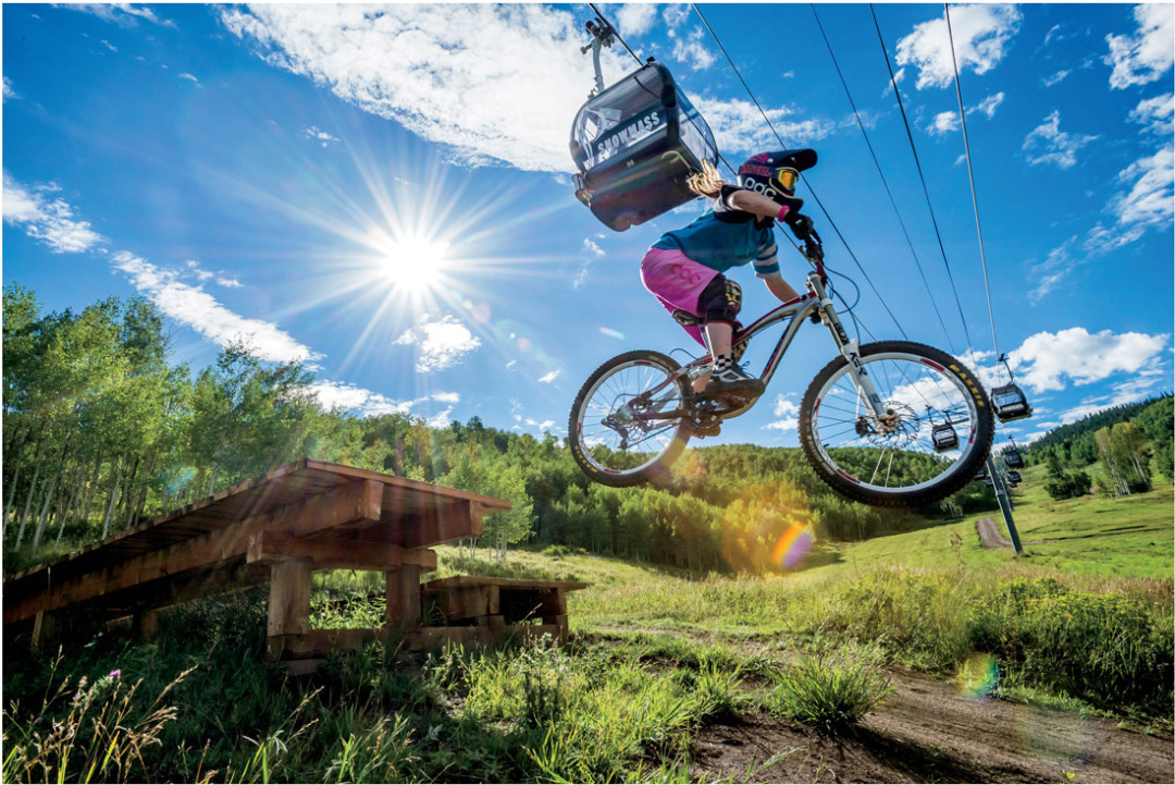
Gravity Biking
Down is the new up in the world of mountain biking, making the best part of riding the main part of riding.
Classic: Prince Creek What makes for a classic gravity ride? In a word, flow. Like park skiers, gravity bikers long for the perfect physics born of sculpted berms, jumps, and other features that corral g-forces, send riders skyward, and culminate in calculated landings. Add it all up, and you have a smooth ride that corners like a roller coaster and pops like a trampoline. Flow.
Like the vintage Chevy Monte Carlo that is its signature feature, Prince Creek is a classic ride. Long before bike design favored rapid descent, the sport’s pioneers were pinning down this trail on old-school Klunkers, navigating modestly technical features like the iconic road-boat tabletop.
Just south of Carbondale, Prince Creek Road snakes up a colorful scrub oak valley. About three miles up, pavement gives way to dirt. Leave a shuttle car and drive another three miles to where the road widens enough to park. The trail starts by crossing the creek to the west. From here, drop in for the trail’s steepest descents, which sport mildly technical roots and rocks; well-worn bridges span the percolating creek. When the singletrack crosses to the east side of Prince Creek Road, follow it to a level, 4WD road that hugs the terrain along an undulating bench, allowing for as much pedaling as you do or don’t want. In less than a mile, return to the first singletrack that leaves the road. It drops downhill to the inside of a steep, left switchback, then converges with multiple trails at “Ginormous,” where all roads flow seamlessly into one through a roller coaster of hips buffed out through years of riding. The fluid fun ends all too soon (mere minutes) but segues into a gentle downhill oscillating through thin scrub oak that offers welcome shade, while hairpin turns challenge your balance and limit your speed on the final leg back to your starting point. If you’ve never ridden Prince Creek, consider a guide. Check Aloha Mountain Cyclery’s group ride schedule (alohamountaincyclery.com), which highlights Prince Creek on select days.
Easy: A Lesson at Bike Snowmass
Unless you’re a seasoned cross-country rider, it’s smart to take a lesson before hopping a ski lift to ride downhill. In scant few hours, Snowmass’s bike school (aspensnowmass.com) teaches basics like braking, shifting, and balancing. Letting gravity pull you downhill (versus pedaling uphill) can be intimidating, but seasoned pros break it down to bite-size chunks that don’t threaten—and might even inspire—new riders, encouraging even the most timid in the pack to get hooked on Snowmass’s growing network of gravity trails.
Epic: En’Mass While the Roaring Fork Valley does not (yet) claim legendary flow like Whistler’s pornographically oversize A-Line, you can piece together a mini-version of a truly epic ride like Moab’s Whole Enchilada starting at the top of Snowmass Mountain and bombing down nearly 3,000 vertical feet of lift-served terrain. Take the gondola, the lift, and your big bike to the top of Elk Camp and drop in on Vapor for rough, steep singletrack peppered with tight berms and loose rock. For the smoothest ride, don’t brake until you reach Valhalla at the top of the gondy.
What Snowmass lacks in diversity, it gives back in sincerity with Valhalla. The gurus who designed Whistler’s perfectly manicured trails engineered this flowy Eden, where buffed-out berms and progressively bigger hits are, like its namesake, the nectar of an aggressively Norse god.
For epic loops, ride and repeat. For a longer patchwork of gravity, cut out halfway where Government Trail crosses Valhalla, pedal a few strokes east to Sequel for turny, rolly singletrack, then join the Tom Blake Trail for a smooth, gradual descent through quaking aspens before crossing Owl Creek Road to take Highline back to the Rodeo lot. There, true gravity devotees can load their bikes on the bus back to the gondola, having barely pedaled a stroke.
Unknown: Sky Mountain Park’s Deadline Trail In gravity-riding centers like Vancouver’s North Shore, where this style of riding was born, bike parks often have no lifts. Instead, they have dedicated uphill routes (often logging roads) gentle enough for full-suspension bikes to pedal up. Downhill-only trails spur off of the uphill and course down variable terrain. As yet, the Roaring Fork Valley has no true one-way loops. Sky Mountain’s Deadline Trail, however, is a close second. Opening on the heels of the park’s new Airline and Cozyline trails, which flow like downhill trails but allow travel both ways, Deadline flows fast from the top of the park (accessed from the Rodeo Lot) down to Highline Trail with added jumps and other features for serious riders to catch serious air. With “recommended” downhill-only travel, Deadline is poised to become the county’s first legitimate downhill trail not served by a lift.
Modus Operandi: Aspen’s hard-core cross-country community will hop a bike to Crested Butte simply for breakfast. For downhiller Tyler Spence, XC is just fitness for the real event. At 15, the future World Cup champion (“it’s realistic,” he says with a confidence that belies his youth) lacks a driver’s license but owns a second-place win at nationals in his division (Junior Extreme, one tier below pro). Spence competes on the valley’s Team Geronimo, which offers private training trails and seasoned coaches. With one eye cast on a World Cup title, the other, for now, is set firmly on brother Tanner, 18, who also races DH. Says the younger Spence: “I’ve been following him my whole career, and now I’m starting to catch up.” Who knows? The downhilling upstart could reach both goals before he’s old enough to see an R-rated movie.
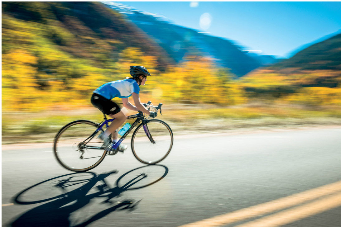
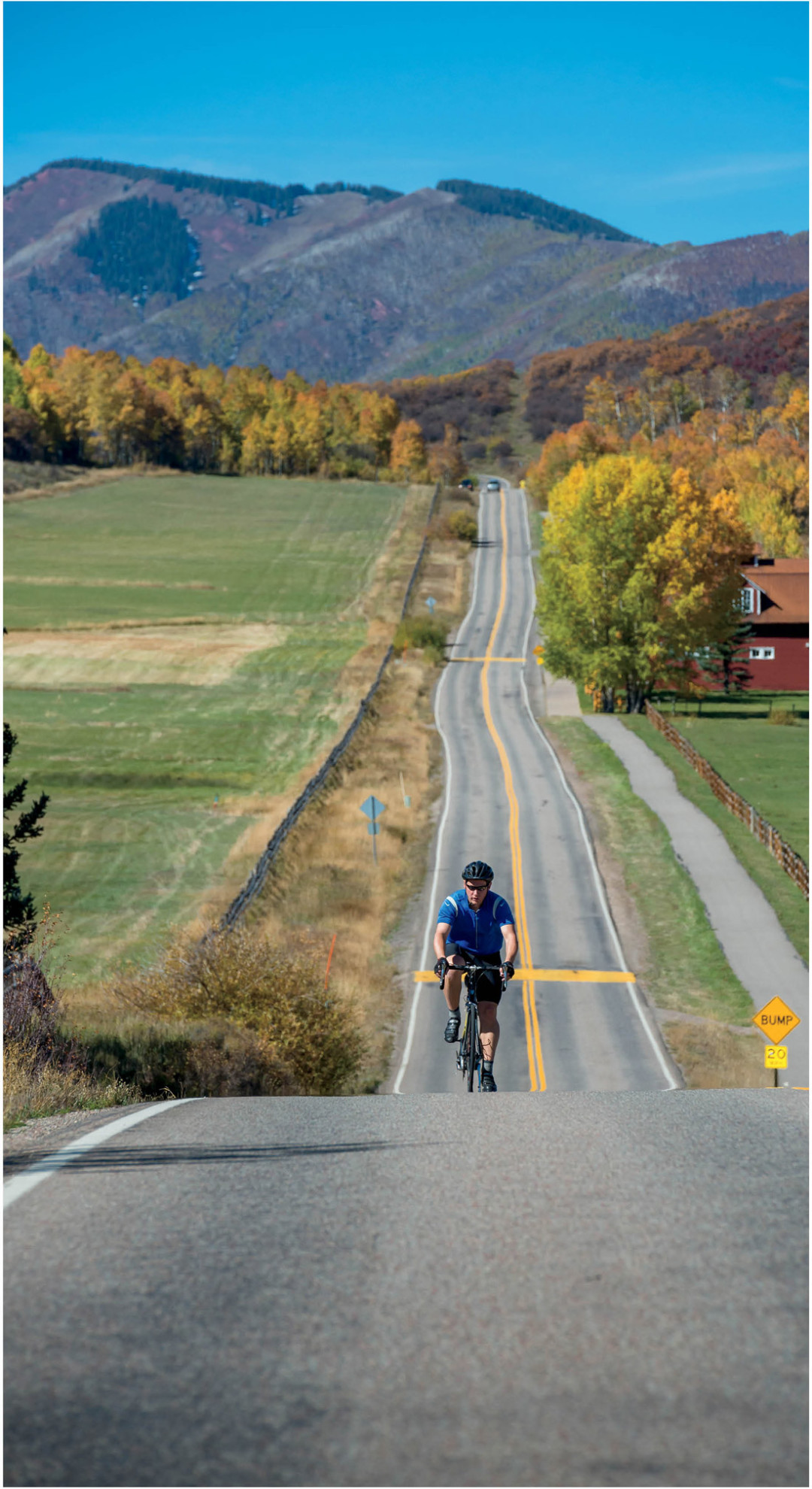
Road Biking
Pro cyclists choose to live and train here for a reason: our paved biking terrain is some of the greatest in the world.
Epic: Independence Pass (to Twin Lakes and back) It’s not just the ouch-my-butt-hurts distance (seventy-three miles) or the quad-quaking vertical (7,600 feet of climbing) or the lung-pinching elevation (12,095 feet at the summit) that makes this ride a notch in the belt of any roadie. The jaw-dropping views, pleasant variety of terrain, and the way the road winds through the high alpine like some kind of exotic snake makes it more of a journey than a bike ride. Pedal past gushing waterfalls, open tundra exploding with wildflowers, massive aspen groves that make you question the interconnectedness of just about everything, and gain a bird’s-eye view from the summit of the surrounding peaks that rivals what you might see from the window of an airplane.
Fuel up in Twin Lakes with lunch on the patio at the Twin Lakes Inn before pedaling the seventeen miles and 3,100 vertical feet back up the east side to the summit. The good news: it’s all downhill from here. This ride is epic even by pro cycling standards: Independence Pass was the highest point reached in any professional cycling race during the Aspen to Breckenridge stage of the 2013 USA Pro Cycling Challenge. And it might’ve even been too hard—it’s been ix-nayed from the course this year.
Classic: Castle Creek/Maroon Creek Aspen roadies talk about this ride with the same amount of bravado they would about a really hot date. Affectionately known as “the sisters”—because of the two valley’s resemblance as striking twins, each with a distinct allure—Maroon Creek Road and Castle Creek Road are the crown jewels of Aspen’s repertoire of world-class road rides. Both offer unparalleled scenery and very few cars—the hallmark of a perfect ride. These routes can be ridden separately, but to tackle them both at once is the standard for anyone who takes their time in the saddle seriously (and, please, you can let go of the sister analogy now).
There’s also no shortage of challenge. You gain 1,600 feet in elevation in the ten-mile ride from downtown Aspen to the Maroon Bells. Once you pass T-Lazy-7 Ranch (at 4.6 miles), it’s straight up and only gets steeper toward the top. After gazing at Pyramid Peak for a while, the Maroon Bells finally appear around mile eight. The twin peaks make their entrance like stage dancers kicking their legs high just after the curtain’s been lifted, the cheers of the nonexistent crowd ring in your head—at least until the last three miles of the climb, the steepest and most punishing yet. Still, whatever suffering you endured is immediately forgotten on the screaming downhill, the closest you’ll come to shouting out a “whoop whoop!” when not on a pair of skis.
Descend back to the roundabout, where the climb begins again. The Castle Creek Valley offers twelve miles and 1,500 vertical feet of climbing with requisite life-is-a-fairy-tale mountain views: snowcapped peaks, plus water cascading over the stone-strewn creek as the accompanying soundtrack. This sister’s personality is a lot more dynamic than her straight-up sibling, with a variety of terrain (flats, steeps, and some fun rollers in the middle) that will require every gear on your chain ring. The good news: this out-and-back route means you can turn around anytime and still have a great ride—either sister guaranteed to satisfy.
Easy: Rio Grande Trail to Woody Creek
There’s no better way to spend a lazy summer afternoon than cruising on the Rio Grande Trail from Aspen down to Woody Creek. We’re talking a paved bike path, we’re talking no cars, we’re talking feet-out-of-the-pedals free-wheeling mostly downhill, the kind of ride you can do with a beer in one hand or with a kid and your grandparents in tow—or both. Cancel out whatever calories you burned with beers and burgers at the Woody Creek Tavern. And don’t think for one second you’re the first person to hire a taxi for the ride back home.
Unheralded: The Frying Pan
The sixty-six-mile out-and-back route from downtown Basalt to the end of Frying Pan Road is a popular training ground for even the most seasoned roadie because of its epic variety of terrain. But it’s also hands-down one of the most scenic routes in the Rockies. You ride alongside the gold-medal fishing waters of the Frying Pan River, up a gentle, rolling grade for the first twelve miles through this immaculate river valley. Four miles up, red rock spires tower over the landscape like a chunk of Utah Canyonlands that mysteriously landed in western Colorado. Flying by, well, fly-fishers feels like a scene out of a Robert Redford movie, their long lines glistening in the sun. Pedaling past the historic past at Sloss Depot, a relic of the old Midland Railroad, feels like a ride-by history lesson. Then climb past Rocky Fork for six miles as the road wraps around Reudi Reservoir, finally topping out at mile seventeen. Enjoy a short reprieve during a five-mile descent into Meredith before the long, slow, ten-mile climb from Thomasville to the end of the road. The gain in elevation means endless views of the surrounding high peaks and wilderness. Because of heavy boater traffic to Reudi Reservoir in the summer months, the best time to attempt this ride is in the late spring and early fall. Don’t count on an easy descent; headwinds that blow up valley all day long mean pedaling downhill until your quads are (ahem) totally fried.
Day job: Landscaping, Aspen Mountain Ski Patrol (22 years)
Modus Operandi: Gonzales isn’t the first Aspen grandma still road racing, but chances are she’s the only fifty-three-year-old woman racing against the men. “I like to try to finish in the top five,” she says of her Wednesday night races with the Aspen Cycling Club. “But I’m happy to be top ten.” She was also pretty happy being a “mid-packer” in the U.S. Pro Challenge the last two summers—against women half her age. How does Gonzales—also a world champion in mountain biking, off-road triathlons, and trail-running races—do it? Just like any serious local athlete with a full time job: before and after work.